

Weather Event: Nicole
Updates found on this page are from community Executive Directors,
corporate team members and the National Hurricane Center.

Update – 10:15 PM EST This is the final update for the weather event known as Nicole, as all of our properties weathered the storm with little disruption and are operational. We'd like to thank our senior living Executive Directors for their efforts during these past few days. Preparation during inclement weather is key – each of them performed professionally under pressure.

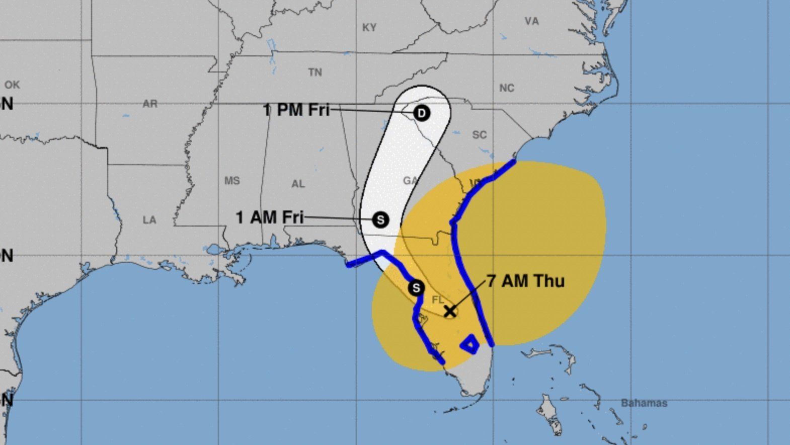
Update – 9:23 AM EST Our Florida, Alabama, and southern Georgia communities were met with rain and high wind gusts; however, they weathered the storm with little disruption. All communities north of central Georgia are experiencing rain, with some high wind gusts. Portions of the southeastern United States are under tornado watches or are expected to be throughout the day. Nicole is making her way through the Southeastern United States and is now a tropical depression bringing rain and dissipating winds. The depression is moving toward the north-northwest near 16 MPH. On the forecast track, the center of Nicole will move across central and northern Georgia this morning and over the western Carolinas later today. Maximum sustained winds are near 35 MPH with higher gusts. Nicole is expected to become a post-tropical cyclone later today, then dissipate tonight or early Saturday.
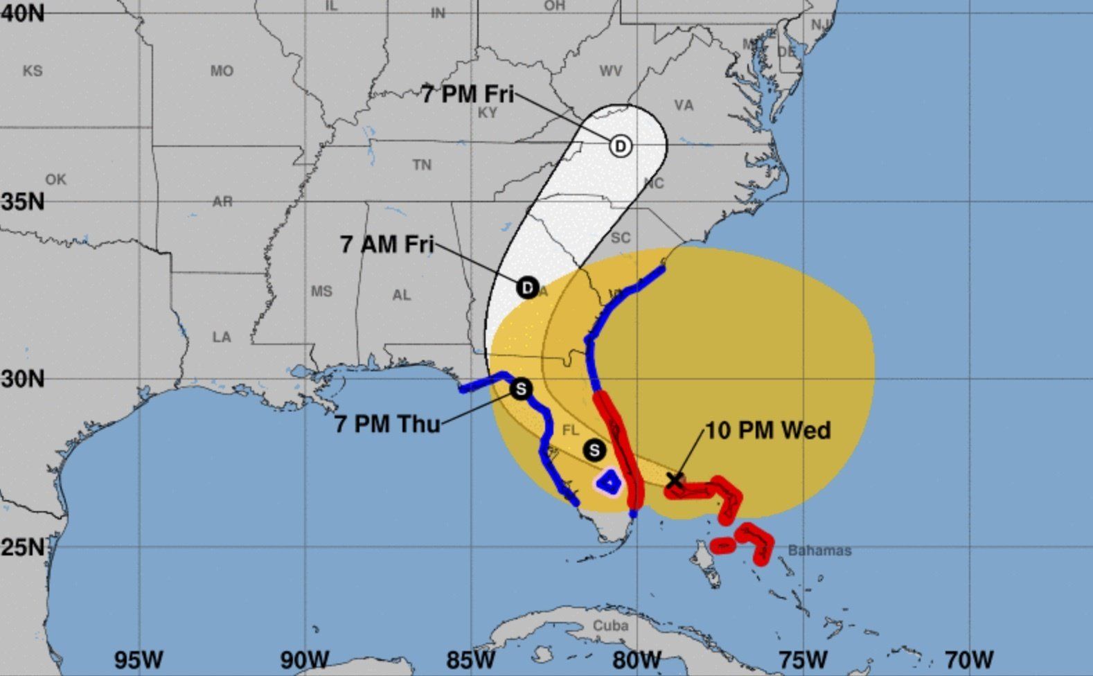
Update – 4:15 PM EST Our communities are reporting very little disruption: The Canopy at Walden Woods lost power briefly and the backup generators worked as tested. Walden Woods has had their power restored. Seagrass Village of Fleming Island had internet and phone service outages, but those services are coming back online sporadically. Most communities in the storm’s path have been experiencing wind, some high gusts and rain. Communities affected are faring well, and those yet to experience Nicole are prepared for her arrival. At the 4:00 PM EST update from the National Hurricane Center, Tropical Storm Nicole is moving toward the northwest near 15 MPH, and this general motion should continue this evening, followed by a turn toward the north tonight. Nicole is expected to accelerate north northeastward on Friday. On the forecast track, the center of Nicole will move along the coast of the Florida Big Bend region for the next several hours before moving across the eastern Florida Panhandle. After that, Nicole should move northward over Georgia later tonight, and then move through the southeastern United States on Friday. Maximum sustained winds are near 45 MPH with higher gusts. These winds are mainly occurring over the Gulf of Mexico to the west of the center. Little change in strength is expected this evening while the center moves along the coast of the Florida Big Bend. Nicole is expected to weaken to a depression over Georgia tonight, and then it is expected to dissipate over the Mid-Atlantic United States by Friday night. Tropical storm force winds extend outward up to 175 miles from the center. A Weather STEM station on the campus of the University of Florida in Gainesville recently reported a wind gust of 54 MPH.
Update – 9:00 AM EST Hurricane Nicole has been downgraded to tropical storm status as she moves up the Florida peninsula. Our communities along Florida’s east coast are faring very well – most have gotten rain and high wind gusts, but nothing that wasn’t expected or managed. Those communities not on the east coast are beginning to feel winds pick up and rain has started. So far, communities are in good shape and spirits. The storm is expected to turn toward the northwest and north-northwest is expected later today and tonight, followed by an acceleration toward the north and north-northeast on Friday. On the forecast track, the center of Nicole will move across central Florida this morning, possibly emerge over the far northeastern Gulf of Mexico this afternoon, and then move across the Florida Panhandle and Georgia tonight and on Friday. Maximum sustained winds have decreased to near 60 MPH with higher gusts. Additional weakening is forecast while Nicole moves over land during the next day or two, and the storm is likely to become a tropical depression over Georgia tonight or early Friday. Nicole remains a large tropical storm with tropical-storm-force winds extending outward up to 450 miles from the center, especially to the north. Daytona Beach, Florida, recently reported sustained winds of 49 MPH with a wind gust of 70 MPH.
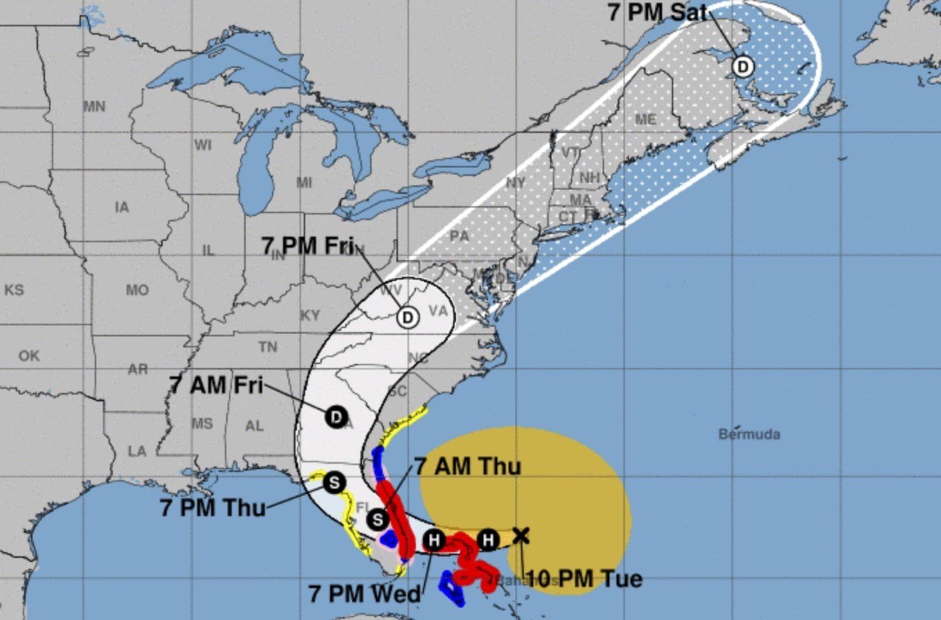
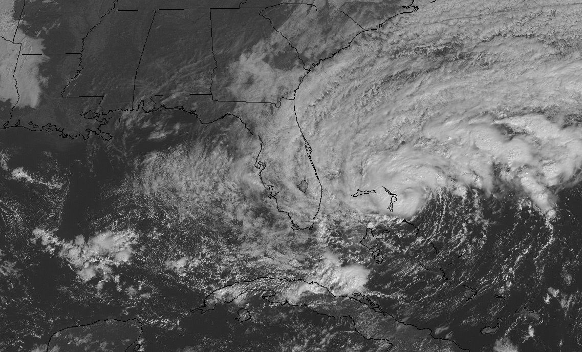
Update – 12:01 AM EST At the 10:00 PM EST update from the National Hurricane Center, Nicole has made its expected turn toward a west-northwestward heading. The system should turn toward the northwest and north during the next day or so while moving along the western side of a mid-level anticyclone, moving over the Florida peninsula and northern Florida. In 36 to 48 hours, Nicole should accelerate north-northeastward. The official track forecast is about the same as the previous one and remains close to the multi-model consensus prediction. The hurricane has little time to strengthen further before making landfall in Florida. Weakening will occur while Nicole moves over Florida, and even though the center may briefly emerge over the extreme northeastern Gulf of Mexico, this is not likely to result in any significant re-intensification. The system should weaken to a depression and become a post-tropical cyclone over the southeastern United States. Nicole should merge with another extratropical low over the eastern United States after 48 hours. Key Messages from the National Hurricane Center Hurricane conditions are expected across portions of the coast of southeast and east-central Florida tonight, where a Hurricane Warning is in effect. Tropical storm conditions will continue along the east coast of Florida, Georgia, and South Carolina within the warning areas into Thursday. Tropical storm conditions are expected to begin along the west coast of Florida tonight and Thursday. A dangerous storm surge is expected along much of the east coast of Florida, portions of coastal Georgia, and the Florida Big Bend along the Gulf coast. The storm surge will be accompanied by large and damaging waves along the Atlantic coast. Residents in the warning area should listen to advice given by local officials. Do not focus on the exact track of Nicole since it is a large storm with hazards extending well to the north of the center, outside of the forecast cone. These hazards will affect much of the Florida peninsula and portions of the southeast United States. Nicole will produce heavy rainfall tonight into Thursday across the Florida Peninsula. Flash and urban flooding will be possible across portions of the Florida Peninsula along with renewed river flooding on the St. Johns River. Isolated flash, urban, and small stream flooding will also be possible on Friday in the Southeast through the southern and central Appalachians, including the Blue Ridge Mountains, and extending northward through west-central Pennsylvania into western New York by Friday night into Saturday.
Update – 12:05 AM EST At the 10:00 PM EST update from the National Hurricane Center, Air Force Hurricane Hunter aircraft indicate Tropical Storm Nicole is close to hurricane strength and is expected to form into a hurricane at some point Wednesday. Nicole is expected to remain at hurricane strength when it reaches the east coast of Florida. Currently, Nicole has tropical-storm-force winds extending outward up to 380 miles from the center, and is moving toward the west-southwest near 10 MPH with a west-southwestward to westward motion that is expected through early Wednesday. A west-northwestward motion is forecast to begin later Wednesday, followed by a turn toward the northwest and north on Thursday and Thursday night. On the forecast track, the center of Nicole will approach the northwestern Bahamas overnight, move near or over those islands on Wednesday, and approach the east coast of Florida within the hurricane warning area Wednesday night or early Thursday. Nicole's center is then expected to move across central and northern Florida into southern Georgia Thursday and Thursday night. Key Messages from the National Hurricane Center Hurricane conditions are expected across portions of the coast of southeast and east-central Florida beginning late Wednesday or Wednesday night, where a Hurricane Warning is in effect. Tropical storm conditions are expected in the Tropical Storm Warning areas in Florida and Georgia beginning early Wednesday. A dangerous storm surge is expected along much of the east coast of Florida and portions of coastal Georgia where a Storm Surge Warning is in effect. The storm surge will be accompanied by large and damaging waves. Residents in the warning area should listen to advice given by local officials. Do not focus on the exact track of Nicole since it is expected to be a large storm with hazards extending well to the north of the center, outside of the forecast cone. These hazards are likely to affect much of the Florida peninsula and portions of the southeast United States. Nicole will produce heavy rainfall Wednesday and Thursday across the Florida Peninsula. Flash and urban flooding will be likely across portions of the Florida Peninsula along with possible renewed river rises on the St. Johns River. On Friday and Saturday, flash, urban and small stream flooding will be possible in the Southeast through the Mid-Atlantic and central Appalachians.
Update – 4:30 PM EST Today, the weather event known as Nicole was upgraded to a Tropical Storm, and is looking like she will strengthen into a hurricane over the next day or so. Our communities throughout the Southeastern United States are preparing as TS Nicole may affect each one in some way or another. Our communities along the east coast of Florida are looking at possible Hurricane-like conditions, while our communities in central Florida and along the Florida's west coast are bracing for possible tropical storm like conditions. Communities in Georgia, South Carolina and even into Virginia might be affected with rain and possible high wind gusts. During a call today with our community Executive Directors, we discussed preparation and processes for storm readiness. Each community is working toward and preparing for Nicole to make landfall. Key Messages from National Hurricane Center Hurricane conditions are expected across portions of the coast of southeast and east-central Florida beginning late Wednesday or Wednesday night, where a Hurricane Warning is in effect. Tropical storm conditions are expected in the Tropical Storm Warning areas in Florida and Georgia beginning early Wednesday. A dangerous storm surge is expected along much of the east coast of Florida and portions of coastal Georgia where a Storm Surge Warning is in effect. The storm surge will be accompanied by large and damaging waves. Residents in the warning area should listen to advice given by local officials. Nicole will produce heavy rainfall Wednesday and Thursday across the Florida Peninsula. Flash and urban flooding will be likely across portions of the Florida Peninsula along with possible renewed river rises on the St. Johns River. On Friday and Saturday, flash, urban and small stream flooding will be possible in the Southeast through the Mid-Atlantic and central Appalachians.
Updated – 10:20 AM EST At the 10:00 AM EST update from the National Hurricane Center, Tropical Storm Nicole is close to hurricane strength and is expected to form into a hurricane at some point today. Maximum sustained winds are near 70 MPH with higher gusts. Once a hurricane, Nicole is expected to remain at hurricane strength until it reaches Florida’s east coast. Currently, Nicole is a large tropical storm with tropical-storm-force winds extending outward up to 460 miles especially to the north of the center. Nicole is moving toward the west near 12 MPH with a turn toward the west-northwest expected tonight, followed by a turn toward the northwest on Thursday, and north or north-northeast on Friday. Nicole's center is then expected to move across central and northern Florida into southern Georgia Thursday and Thursday night, and then across the Carolinas Friday and Friday night. Key Messages from The National Hurricane Center Hurricane conditions are expected across portions of the coast of southeast and east-central Florida beginning this evening or tonight, where a Hurricane Warning is in effect. Tropical storm conditions have begun along the east coast of Florida in the warning areas and will spread northward to Georgia and South Carolina later today. Tropical storm conditions are expected to begin along the west coast of Florida within the warning area this evening or tonight. A dangerous storm surge is expected along much of the east coast of Florida, portions of coastal Georgia, and the Florida Big Bend along the Gulf coast. The storm surge will be accompanied by large and damaging waves along the Atlantic coast. Residents in the warning area should listen to advice given by local officials. Do not focus on the exact track of Nicole since it is a large storm with hazards extending well to the north of the center, outside of the forecast cone. These hazards will affect much of the Florida peninsula and portions of the southeast United States. Nicole will produce heavy rainfall today into Thursday across the Florida Peninsula. Flash and urban flooding will be possible across portions of the Florida Peninsula along with river rises on the St. Johns River. Isolated flash, urban, and small stream flooding will also be possible on Friday in the Southeast through the southern and central Appalachians, including the Blue Ridge Mountains, and extending northward through west central Pennsylvania into western New York by Friday night.

Update – 9:30 AM EST Our communities are preparing for the storm by taking the necessary precautions such as checking and testing generators, ensuring adequate amounts of food and water are on hand, and going through our inclement weather processes for the safety of our residents, guests, and team members. Each senior living community will follow state, county, and local authority mandates as required. Key Messages from National Hurricane Center Nicole will produce heavy rainfall Wednesday and Thursday across the Florida peninsula. Flash and urban flooding will be possible across portions of the Florida peninsula along with renewed river rises for portions of the St. Johns River. Flash, urban and small stream flooding will be possible in southeast Georgia and portions of South Carolina Thursday into Thursday night. Hurricane conditions are possible across portions of the coast of the southeast and east-central Florida beginning late Wednesday or Wednesday night, where a Hurricane Watch is in effect. Tropical storm conditions are expected in the Tropical Storm Warning areas in Florida and Georgia beginning early Wednesday. A dangerous storm surge is expected along much of the east coast of Florida and portions of coastal Georgia where a storm surge warning is in effect. the storm surge will be accompanied by large and damaging waves. For the latest storm updates by the National Hurricane Center, please visit https://www.nhc.noaa.gov/ Florida Gov. Declares State of Emergency Florida Gov. Ron DeSantis has issued Executive Order (EO) 22-253 , declaring a State of Emergency for 34 counties in the potential path of Subtropical Storm Nicole. Gov. DeSantis has issued the EO in an abundance of caution so communities can prepare and families and businesses can create a plan and gather necessary resources in the event that Subtropical Storm Nicole gains in strength. The Governor’s Office and Florida Dept. of Emergency Management are in constant contact with local government officials from all 67 counties, the National Hurricane Center, and the National Weather Service. "While this storm does not, at this time, appear that it will become much stronger, I urge all Floridians to be prepared and to listen to announcements from local emergency management officials," Gov. Ron DeSantis said. "We will continue to monitor the trajectory and strength of this storm as it moves towards Florida." Regardless of the intensity or exact path of Subtropical Storm Nicole, Floridians are reminded to prepare for an increased risk of coastal flooding, heavy winds, rain, rip currents, and beach erosion. Wind gusts can be expected as soon as today along Florida’s East Coast. Florida Counties under a State of Emergency: Brevard, Broward, Charlotte, Citrus, Clay, Collier, DeSoto, Duval, Flagler, Glades, Hardee, Hendry, Highlands, Hillsborough, Indian River, Lake, Lee, Manatee, Martin, Miami-Dade, Nassau, Okeechobee, Orange, Osceola, Palm Beach, Pasco, Polk, Putnam, Sarasota, Seminole, St. Johns, St. Lucie, Sumter, and Volusia

Update – 3:25 PM EST Each one of our senior living communities within the Cone of Uncertainty is preparing for Nicole and monitoring its movement. The storm is moving toward the northwest near 9 mph (15 km/h). A slower northwestward motion is expected later this afternoon through tonight. A turn toward the west or west-southwest is then forecast to begin by Tuesday night and that motion should continue through early Thursday. On the forecast track, the center of Nicole will approach the northwestern Bahamas on Tuesday and Tuesday night, move near or over those islands on Wednesday, and approach the east coast of Florida Wednesday night. Maximum sustained winds are near 45 mph (75 km/h) with higher gusts. Gradual strengthening is forecast during the next few days, and Nicole is forecast to be at or near hurricane intensity by Wednesday or Wednesday night while it is moving near or over the northwestern Bahamas. For more information, please visit: https://www.nhc.noaa.gov/
